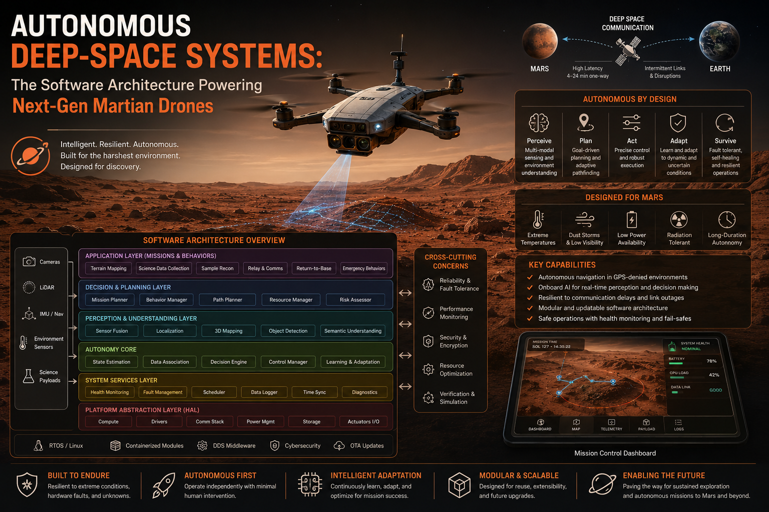
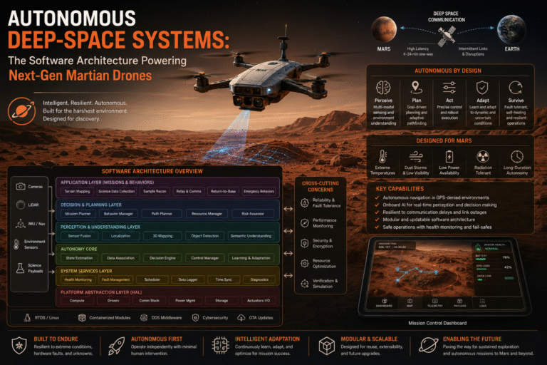
When NASA’s Ingenuity Mars Helicopter took its historic first flight, it fundamentally changed the mechanics of planetary exploration. Proving that powered, controlled flight is possible in an atmosphere less than 1% as dense as Earth’s was a monumental achievement. However, as we look to the next generation of aerial exploration—such as the conceptual SkyFall fleet architecture—the engineering challenge transitions from basic aerodynamics to deep software autonomy.
Because Mars sits an average of 140 million miles away from Earth, radio signals can take anywhere from 4 to 24 minutes to travel one way. This immense communication lag makes real-time “joystick” piloting completely impossible. When a deep-space drone takes off, it must act as a fully self-contained robotic explorer.
This guide pulls back the curtain on the specialized software stacks, real-time operating systems (RTOS), and computer vision pipelines that allow space drones to perceive, reason, and navigate entirely on their own.
1. The Hardware Constraint: Flight Computing at the Edge
Before diving into the code, it is vital to understand the extreme computational boundaries imposed by outer space. Unlike a commercial drone on Earth that can carry heavy multi-core processors or stream data to cloud servers, a space drone operates on a highly restricted power budget under intense cosmic radiation.
To survive, the flight computer must balance processing speed with radiation hardening. Engineers frequently deploy an asymmetric dual-core architecture:
- The Control Core (Radiation-Hardened MCU): A low-power, ultra-reliable microprocessor running a deterministic Real-Time Operating System (like VxWorks or RTEMS). This core handles the critical microsecond-level flight loops—such as adjusting rotor blade pitch or balancing active stabilization. If a stray cosmic ray flips a bit in memory, this core is designed to fault-recover instantly without dropping out of the sky.
- The Vision Core (High-Performance SoC): A more powerful, commercial-grade system-on-chip (similar to high-end smartphone processors). This core runs a customized, embedded Linux partition dedicated strictly to processing heavy camera streams, hazard maps, and autonomous path-planning algorithms.
2. The Computer Vision Pipeline: Velocity Sensing via Optical Flow
In a stark, featureless alien landscape without a GPS network or a stable magnetic field for a compass, a drone cannot easily determine its position or speed. To navigate, the software relies on a specialized framework called Visual Inertial Odometry (VIO).
[ Downward Navigation Camera ] ──► Extracts Visual Features (Rocks, Ripples)
                                             │
                                             ▼
[ Real-Time Flight Loop ]    ◄── Computes Velocity Vector (Optical Flow)
The drone’s downward-facing navigation camera captures high-resolution imagery at 30 frames per second. The vision algorithm continuously processes these images through a sequence of mathematical layers:
- Feature Extraction: The software scans the frame to identify distinct geometric anchor points, such as the edge of a jagged rock or the crest of a sand ripple.
- Optical Flow Tracking: As the drone moves, the algorithm tracks how those specific anchor points shift position relative to the camera sensor from one frame to the next.
- Sensor Fusion: The software feeds this visual displacement data into an Extended Kalman Filter (EKF), fusing it with raw accelerometer and gyroscope inputs from the Inertial Measurement Unit (IMU). This allows the system to calculate its precise altitude, roll, pitch, and cross-wind drift velocity 30 times a second.
3. Generative AI and Autonomous Hazard Avoidance
While previous proof-of-concept models flew pre-planned trajectories over flat surfaces, next-gen drones utilize onboard Generative AI and Hazard Avoidance Maps to explore highly irregular terrain like crater rims, cliffs, and deep ravines.
During the descent phase of a flight, the vision core uses stereo-imaging or LiDAR arrays to generate a real-time 3D height map of the terrain directly beneath it. The onboard AI classifies the terrain into structural safety categories:
Safety Score = f(Surface Slope,Obstacle Height,Silt Density)
If the algorithm detects a slope greater than 15 degrees or a rock cluster higher than 10 centimeters within its targeted landing zone, the path planner autonomously overrides the initial flight plan. It computes a localized vector shift to steer the vehicle toward a safer, smoother alternative landing spot (airfield), all without sending a single byte of data back to human operators on Earth.
4. Overcoming The Thin Atmosphere: Software-Driven Lift Dynamics
Aerodynamics on Mars require a unique software compensation layer. Because the air density is so low, rotor blades must spin between 2,400 to 2,800 RPM just to achieve lift—nearly ten times faster than a standard helicopter on Earth.
At these extreme rotational velocities, the tips of the rotor blades travel dangerously close to—and sometimes exceed—the local speed of sound (Mach 1). This creates localized sonic booms and unpredictable aerodynamic drag shifts across the blade surface. To counter this, the flight control software utilizes Adaptive Control Loops. The system constantly measures the rotor motor’s current draw and rotational resistance, dynamically micro-adjusting the blade pitch angles multiple times per second to prevent structural stalling and maximize energy efficiency.
5. Conclusion: The Foundation for Multi-Planetary Autonomy
By shifting the burden of navigation from distant human controllers to real-time onboard algorithms, deep-space software engineering is unlocking entirely new frontiers across our solar system. The exact computer vision concepts, deterministic operating systems, and autonomous path-planning frameworks currently being refined in the thin air of Mars will serve as the architectural foundation for future robotic missions—scouting paths for human astronauts, mapping subsurface ice, and exploring the skies of worlds far beyond our own.
Reference Links
- NASA Jet Propulsion Laboratory (JPL) Robotics Research: https://www.jpl.nasa.gov/
- Caltech Center for Autonomous Systems and Technologies (CAST): https://cast.caltech.edu/
- IEEE Robotics and Automation Society: https://www.ieee-ras.org/
Explore how NASA’s Perseverance Rover recently used onboard AI to execute completely autonomous drives on Mars, illustrating how real-world space missions rely on standalone edge intelligence to navigate treacherous terrain without real-time human intervention.

+ There are no comments
Add yours