
Key Highlights
- Delhi’s Drainage Master Plan reveals elevated roads and metro corridors are significantly disrupting natural water flow patterns, requiring ₹57,000 crore investment over 30 years
- Western Peripheral Expressway impact has significantly altered flow patterns within the Najafgarh basin, disrupting regional hydrological balance
- Punjab floods crisis exacerbated by elevated highways lacking adequate culverts, with Parliamentary Committee identifying 346 obstruction spots across state highways
- Chennai’s infrastructure challenge requires comprehensive hydrological studies integrating drainage considerations into elevated corridor design from planning stages
- Water-sensitive urban design revolution emerging as critical solution, with blue-green infrastructure providing flood mitigation while maintaining connectivity
The Unintended Consequences of Urban Progress
The surge in elevated infrastructure projects across India’s urban and peri-urban regions represents one of the most ambitious attempts to solve chronic traffic congestion. From the 135-kilometer Western Peripheral Expressway to Delhi’s expanding metro network and the proposed 55-kilometer elevated Ring Road, these engineering marvels promise to revolutionize urban mobility. nationalheraldindia
However, beneath the gleaming concrete structures lies a growing environmental crisis that planners are only beginning to comprehend. The Delhi Drainage Master Plan, released in 2025, has sounded a crucial alarm: these elevated corridors are fundamentally disrupting natural water flow patterns, transforming solutions into sources of new urban challenges.
The significance of this issue extends far beyond local waterlogging. As India rapidly urbanizes, with 68% of the population expected to live in cities by 2050, the intersection of infrastructure development and environmental sustainability has become critical for the nation’s future resilience. The choices made today in infrastructure planning will determine whether Indian cities can adapt to increasing climate variability or remain perpetually vulnerable to flood disasters.
Understanding Natural Water Systems: The Foundation of Urban Resilience
The Complex Web of Natural Drainage
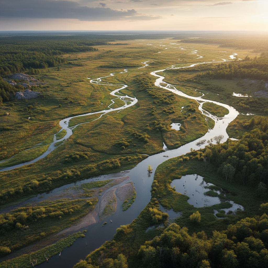
Natural drainage systems represent one of nature’s most sophisticated engineering achievements, developed over millennia to efficiently manage water movement across landscapes. These systems comprise surface runoff patterns, seasonal streams, rivers, floodplains, and groundwater recharge zones that work in intricate harmony to maintain regional water balance.
Surface runoff follows topographical gradients, with water naturally flowing from higher to lower elevations through established channels. Floodplains serve as temporary storage areas during peak flow periods, reducing downstream pressure while allowing gradual water release. Groundwater recharge zones ensure long-term water security by replenishing aquifers that support both urban and rural water supplies.
The Delhi region, for instance, is divided into seven major drainage basins ultimately discharging into the Yamuna River. These basins have evolved over geological time to handle seasonal variations, with swampy areas along flood plains providing natural flood mitigation. Disrupting these established patterns through infrastructure development creates cascading effects throughout the entire hydrological system.
Hydrological Services: Beyond Water Transport
Natural drainage systems provide multiple ecosystem services essential for urban sustainability:
Flood Control: Natural channels and floodplains provide temporary water storage, reducing peak flood levels by 20-40% compared to modified systems.
Groundwater Recharge: Permeable surfaces and natural infiltration areas maintain water table levels, supporting long-term water security.
Sediment Management: Natural systems transport and deposit sediments in appropriate locations, preventing downstream channel degradation.
Biodiversity Support: Riparian corridors provide wildlife habitats and ecological connectivity essential for urban biodiversity.
Climate Regulation: Wetlands and water bodies provide micro-climate control, reducing urban heat island effects by 2-5°C.
Infrastructure Planning Gaps: The Root of the Problem
Inadequate Hydrological Assessment
The fundamental issue lies in the absence of comprehensive hydrological studies during infrastructure planning phases. Most elevated corridor projects rely on basic topographical surveys without detailed analysis of surface water flow patterns, groundwater dynamics, or seasonal variation impacts.
Critical Planning Deficiencies:
- Limited baseline hydrological data collection spanning insufficient time periods
- Inadequate drainage basin mapping at project and regional scales
- Insufficient integration of meteorological data with infrastructure design
- Lack of cumulative impact assessment considering multiple projects
- Poor coordination between transport and water resource agencies
Design Limitations in Elevated Structures
Current elevated infrastructure design focuses primarily on structural integrity and traffic flow while inadequately addressing hydrological connectivity. Concrete pillars, embankments, and solid structures create barriers that fundamentally alter water movement patterns.
Structural Impediments:
- Closely spaced pillars creating flow restrictions in natural channels
- Solid embankments blocking lateral water movement
- Inadequately sized culverts causing upstream ponding and downstream flooding
- Poor drainage integration with existing natural systems
- Absence of permeable surfaces increasing overall runoff volumes
Case Study Analysis: Western Peripheral Expressway and Regional Impact
The Najafgarh Basin Disruption
The Western Peripheral Expressway (WPE), completed in 2018 at a cost of ₹6,400 crore, exemplifies the unintended hydrological consequences of elevated infrastructure. This 135-kilometer corridor was designed to divert heavy traffic around Delhi, reducing pollution and congestion within the capital.
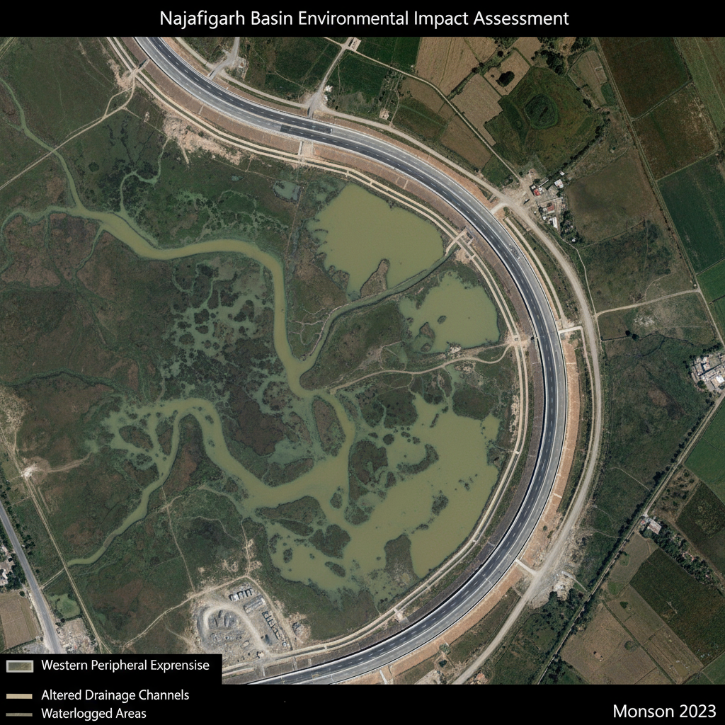
However, the Delhi Drainage Master Plan specifically identifies WPE as significantly impacting flow patterns within the Najafgarh basin. This basin, covering substantial areas of southwest Delhi and adjoining Haryana, has experienced altered drainage patterns affecting both rural and urban areas. devdiscourse
Documented Impacts:
- Changed regional water flow affecting agricultural areas in Haryana
- Increased waterlogging in downstream Delhi areas during monsoons
- Disrupted natural flood channels leading to unexpected inundation patterns
- Reduced groundwater recharge in traditional infiltration zones
- Agricultural distress due to altered soil moisture patterns
Punjab Floods: Highway Infrastructure Exacerbating Natural Disasters
The 2025 Punjab floods provide stark evidence of how inadequate infrastructure planning amplifies natural disasters. The Parliamentary Committee on Agriculture found that elevated highways significantly contributed to flood severity by obstructing natural field drainage.
Critical Findings:
- 346 obstruction spots identified across national and state highways
- Three-kilometer highway stretch from Kalabari to Chakawadi village completely lacking culverts
- Kartarpur Corridor flooding directly attributed to inadequate highway drainage design
- 174,000 acres of crop destruction in Muktsar district due to blocked drainage channels
- 236 villages submerged during 2013 floods partly due to infrastructure obstructions
Gurdaspur MP Sukhjinder Singh Randhawa’s documentation reveals NHAI’s failure to construct adequate drainage infrastructure, leading to religious and culturally significant areas like the Kartarpur Corridor experiencing severe waterlogging.
Technological Solutions: Eco-Engineering and Water-Sensitive Design
Eco-Engineering Approaches
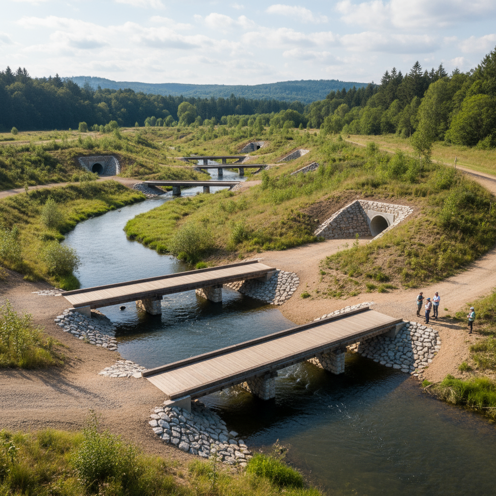
Modern eco-engineering solutions offer pathways to maintain transport connectivity while preserving hydrological integrity. These approaches integrate engineered structures with natural processes, creating infrastructure that supports both human mobility and environmental sustainability.
Innovative Design Solutions:
- Adequately sized culverts designed for 100-year flood events rather than minimum standards
- Bridge designs incorporating natural channel characteristics and flow patterns
- Permeable embankments allowing lateral water movement while maintaining structural integrity
- Bio-engineered slope protection using vegetation and natural materials
- Integrated drainage systems connecting infrastructure with existing natural networks
ECO-MSE flood defense systems, approved by the UK Environment Agency, demonstrate advanced approaches using non-woven geotextile bags that allow water passage while preventing erosion. These systems achieve 100+ year lifespans while supporting natural vegetation growth and biodiversity enhancement.
Water-Sensitive Urban Design (WSUD) Integration
Water-Sensitive Urban Design represents a paradigm shift toward infrastructure that works with natural systems rather than against them. This approach transforms urban areas into “sponge cities” capable of absorbing, filtering, and managing stormwater naturally.
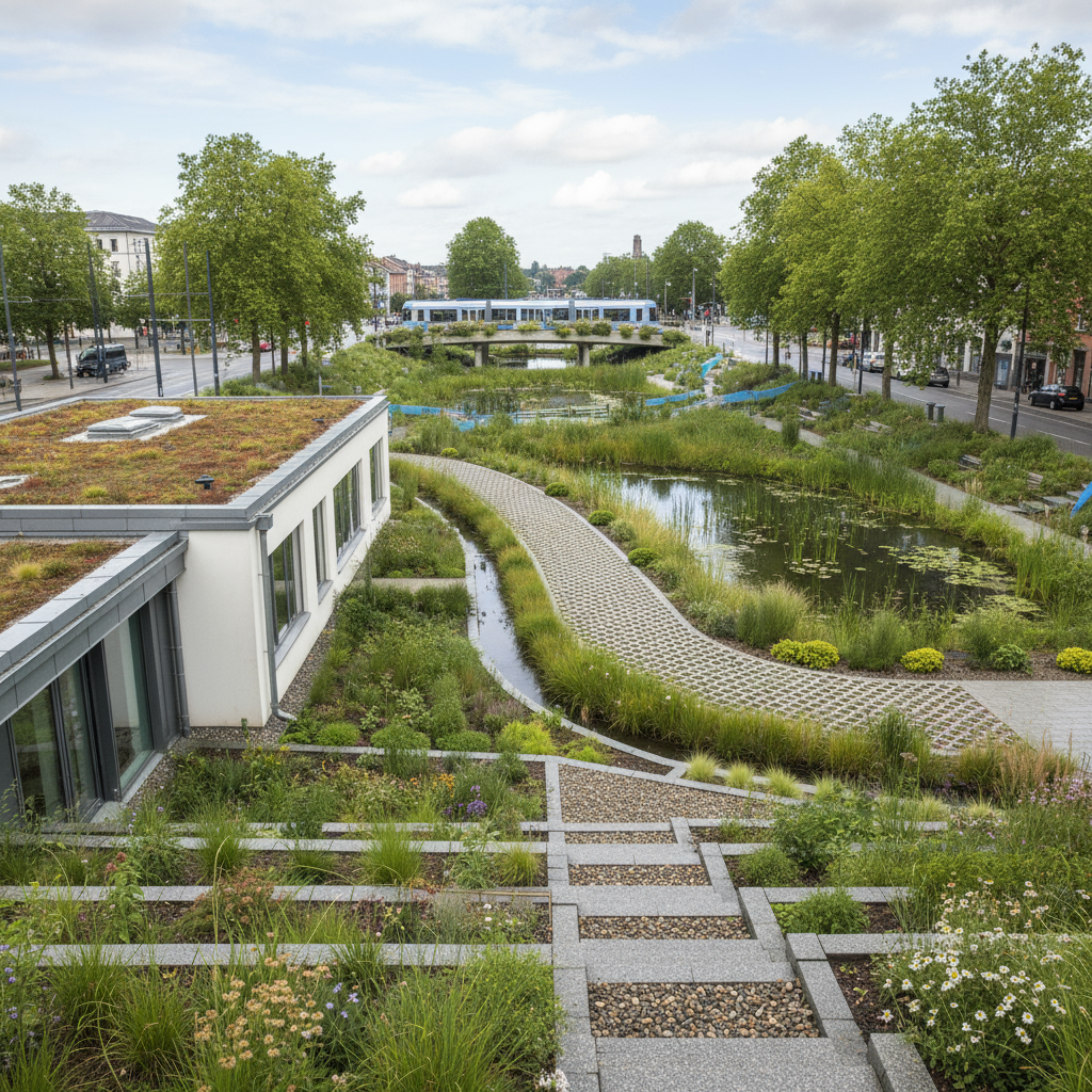
WSUD Components:
- Rain gardens and bioswales filtering runoff while providing urban greenery
- Permeable pavements allowing water infiltration while supporting vehicle loads
- Constructed wetlands treating stormwater while creating biodiversity habitats
- Green corridors connecting natural areas while providing flood storage
- Detention-retention-recharge systems managing peak flows sustainably
The WRI India TheCityFix Labs has successfully piloted nature-based solutions in Mumbai educational institutions, demonstrating practical applications of hybrid systems combining constructed wetlands, organic filtration, and groundwater recharge technologies. nbs4india
Policy Framework: Governance and Regulatory Reform
Environmental Impact Assessment Enhancement
Current Environmental Impact Assessment (EIA) processes require substantial strengthening to address hydrological impacts comprehensively. The Chennai Peripheral Ring Road EIA identified critical water management challenges, highlighting the need for integrated assessment approaches.
EIA Reform Requirements:
- Mandatory hydrological studies using 30-year rainfall data and Digital Elevation Models
- Comprehensive drainage basin mapping at 1:50,000 scale minimum
- Cumulative impact assessment considering all existing and planned infrastructure
- Climate change scenarios incorporation in flood risk modeling
- Community consultation on historically significant water channels
Inter-Agency Coordination Mechanisms
The current fragmented approach to infrastructure planning requires institutional reform enabling cross-sectoral coordination between transport, water resources, and urban development agencies.
Coordination Framework:
- Integrated planning committees with representation from all relevant ministries
- Shared databases providing real-time hydrological and infrastructure information
- Standardized assessment protocols for infrastructure water impact evaluation
- Joint funding mechanisms supporting multi-benefit infrastructure projects
- Performance monitoring systems tracking hydrological health indicators
Way Forward: Integrated Solutions for Sustainable Development
Immediate Policy Interventions
Regulatory Reform:
- Amendment of EIA guidelines mandating comprehensive hydrological assessment
- Integration of drainage considerations in all elevated infrastructure projects
- Standardization of culvert and bridge design incorporating ecological functionality
- Mandatory water impact bonds for large infrastructure projects
Technical Capacity Building:
- Training programs for engineers and planners on water-sensitive design
- Research partnerships between academia and infrastructure agencies
- Technology transfer programs showcasing international best practices
- Professional certification in eco-engineering approaches
Long-term Structural Changes
Institutional Innovation:
- National Water-Infrastructure Coordination Agency providing technical oversight
- Regional drainage authorities managing basin-scale water systems
- Urban resilience indices measuring infrastructure-environment integration
- Community participation mechanisms in infrastructure planning
Financial Mechanisms:
- Green infrastructure bonds supporting nature-based solutions
- Performance-based contracts rewarding hydrologically sensitive design
- Insurance frameworks incorporating flood risk reduction benefits
- Carbon credit systems for natural drainage restoration
Technology and Innovation Pathways
Research Priorities:
- AI-powered hydrological modeling for real-time infrastructure impact assessment
- Nature-based solution optimization for Indian climatic conditions
- Cost-effectiveness analysis of eco-engineering versus conventional approaches
- Community-based monitoring systems for drainage health indicators
The crisis of elevated infrastructure disrupting natural water systems represents both a significant challenge and an unprecedented opportunity for Indian urban development. The evidence from Delhi’s drainage crisis, Punjab’s flood disasters, and Chennai’s infrastructure challenges demonstrates that business-as-usual approaches are no longer viable in an era of climate variability and rapid urbanization.
The solution lies not in abandoning infrastructure development but in fundamentally reimagining how we design and implement these critical projects. Water-sensitive urban design, eco-engineering approaches, and nature-based solutions offer proven pathways to maintain essential connectivity while preserving the hydrological integrity that sustains urban resilience.
The ₹57,000 crore investment outlined in Delhi’s Drainage Master Plan represents just one city’s recognition of the cost of inadequate planning. Across India, the choice is clear: invest in integrated, science-based planning that respects natural systems, or face escalating costs from flood disasters, infrastructure failures, and environmental degradation.
Success requires coordinated action across multiple levels – from policy reform and institutional innovation to technical capacity building and community engagement. The cities that embrace this integrated approach will not only solve immediate drainage challenges but position themselves as models of sustainable urban development for the 21st century.


+ There are no comments
Add yours