
In recent years, urban flooding has emerged as one of the most alarming consequences of rapid urbanization and climate change. Major cities like Mumbai, Chennai, Delhi, and Bengaluru are frequently in the headlines during monsoon season—not for the rains themselves, but for the havoc they cause. Streets resemble rivers, transport systems break down, and thousands of lives are thrown into disarray. The recent deluges in cities like Gurugram and Bengaluru are not one-off anomalies, but signs of a deeper problem: the absence of precise, hyperlocal weather forecasts that could help prepare for and mitigate these urban disasters.
Understanding Urban Flooding
What Is Urban Flooding?
Urban flooding refers to the inundation of land in a built environment, particularly in densely populated areas. Unlike riverine floods, which are often seasonal and occur due to river overflow, urban floods result from high-intensity rainfall overwhelming drainage systems. When natural water absorption systems like wetlands are replaced by impermeable surfaces like concrete and asphalt, water accumulates faster than it can be drained.
Causes of Urban Flooding
- Inadequate Drainage Infrastructure
- Encroachment on Natural Water Bodies
- Unregulated Urbanization
- Intense and Sudden Rainfall Events
- Poor Urban Planning and Maintenance
These factors, when combined with climate variability, create the perfect storm—literally.
Case Studies: Cities Underwater
Bengaluru (2022 & 2023)
Once known for its pleasant climate, Bengaluru witnessed severe flooding in 2022 and 2023. Localities like Whitefield and Sarjapur were submerged due to cloudbursts and poor drainage. The city’s IT corridors were paralyzed for days.
Mumbai (Every Monsoon Season)
Mumbai faces chronic urban flooding nearly every year. Despite investments in pumping systems, short-duration high-intensity rains continue to bring India’s financial capital to a halt.
Gurugram (2024)
A cloudburst in July 2024 overwhelmed the city within hours. Roads, underpasses, and even metro systems were flooded, illustrating the need for micro-level weather alerts.
Chennai (2021 & 2023)
From the 2015 disaster to repeated submergence in subsequent years, Chennai has become a poster city for poor urban flood preparedness.
The Forecasting Gap: Where We Fall Short
Limitations of Current Weather Systems
India’s traditional weather forecasting methods are designed for large geographic areas, not specific localities. Cities, however, are microclimates where a few kilometers can mean the difference between a dry street and a flooded home.
The Communication Lag
Even when rainfall is predicted, forecasts are often not communicated effectively to local authorities or the general public. Alerts may come late or in technical language not easily understood.
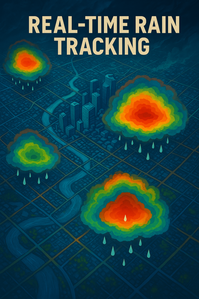
What Are Hyperlocal Weather Forecasts?
Hyperlocal forecasts are high-resolution, neighborhood-level weather predictions generated using advanced technology, including AI and satellite data. These forecasts can provide:
- Real-time rainfall tracking
- 1-km or even street-level predictions
- Minute-by-minute updates
- Alerts customized to specific wards or neighborhoods
How Hyperlocal Forecasts Can Help
Early Warnings Save Lives
Hyperlocal alerts can inform residents before flooding begins, giving them time to safeguard assets, reroute travel, or evacuate.
Empowering Urban Planners
Urban planners can design better drainage systems if they know which areas are chronically prone to waterlogging based on precise data.
Assisting Emergency Responders
First responders need to know which pockets of a city are affected. Hyperlocal forecasts help in efficient deployment of rescue teams.
Business Continuity
IT companies, manufacturing units, and commercial hubs can plan better with localized weather intelligence, ensuring minimum disruption.
The Role of Technology and Data
Satellite Imaging
Real-time satellite data can offer imagery of raincloud movement, water accumulation zones, and atmospheric conditions.
IoT Devices and Weather Stations
Placing low-cost sensors and weather stations at ward-level enables the collection of granular data crucial for real-time forecasting.
AI and Machine Learning
By analyzing historical data, AI can predict flooding patterns in micro-zones, enhancing forecasting precision.
Mobile Apps and Dashboards
Weather apps with geotagging capabilities can send alerts to users based on their exact location, rather than city-wide messages.
Government Initiatives and Gaps
Efforts by IMD and IITM
The Indian Meteorological Department and Indian Institute of Tropical Meteorology are developing high-resolution models like the Bharat Forecasting System. However, operational integration into city governance is still slow.
Smart Cities Mission
While some cities under the Smart Cities Mission are adopting tech-driven weather tracking tools, the progress is uneven and often pilot-level.
Policy Vacuum
There is still no national framework mandating hyperlocal forecasting integration into urban governance or disaster management.
International Models India Can Learn From
Tokyo, Japan
Tokyo has developed an AI-integrated flood alert system with neighborhood-level alerts and automated drainage management.
New York City, USA
NYC’s hyperlocal climate dashboard informs city agencies and residents with block-level rainfall and flood risk data.
Singapore
Singapore uses a network of more than 100 weather sensors and a central AI-based forecasting system for real-time flood alerts.
The Economic Impact of Urban Flooding
Urban floods are not just humanitarian crises but economic black holes. In 2023 alone, India suffered an estimated $9 billion in urban flood-related damages. Lost productivity, damaged infrastructure, and healthcare costs are just the tip of the iceberg.
Public Awareness and Community Preparedness
Role of Media
Timely and accurate media reporting can amplify official forecasts and alert communities.
School and Community Training
Awareness drives, drills, and education campaigns can make local populations more responsive to flood warnings.
Citizen Science
People with access to rain gauges and smartphones can contribute real-time data to civic databases.
Conclusion: A Call to Forecast Better
As Indian cities continue to grow, so too does their vulnerability to climate-induced urban flooding. Hyperlocal weather forecasting isn’t a luxury or future vision—it’s an urgent need. With the right mix of policy, technology, and public participation, India can turn the tide on urban flooding disasters.
Let’s forecast not just the weather, but a safer urban future.


+ There are no comments
Add yours