
Key Highlights
✅ Massive Investment: PM Gati Shakti launched October 13, 2021 as ₹100 lakh crore ($1.2 trillion) transformative infrastructure initiative integrating 16 ministries and 44 departments on single digital platform
✅ GIS Revolution: 200+ geospatial data layers developed by BiSAG-N using ISRO satellite imagery covering infrastructure, forests, economic zones, utilities enabling evidence-based planning
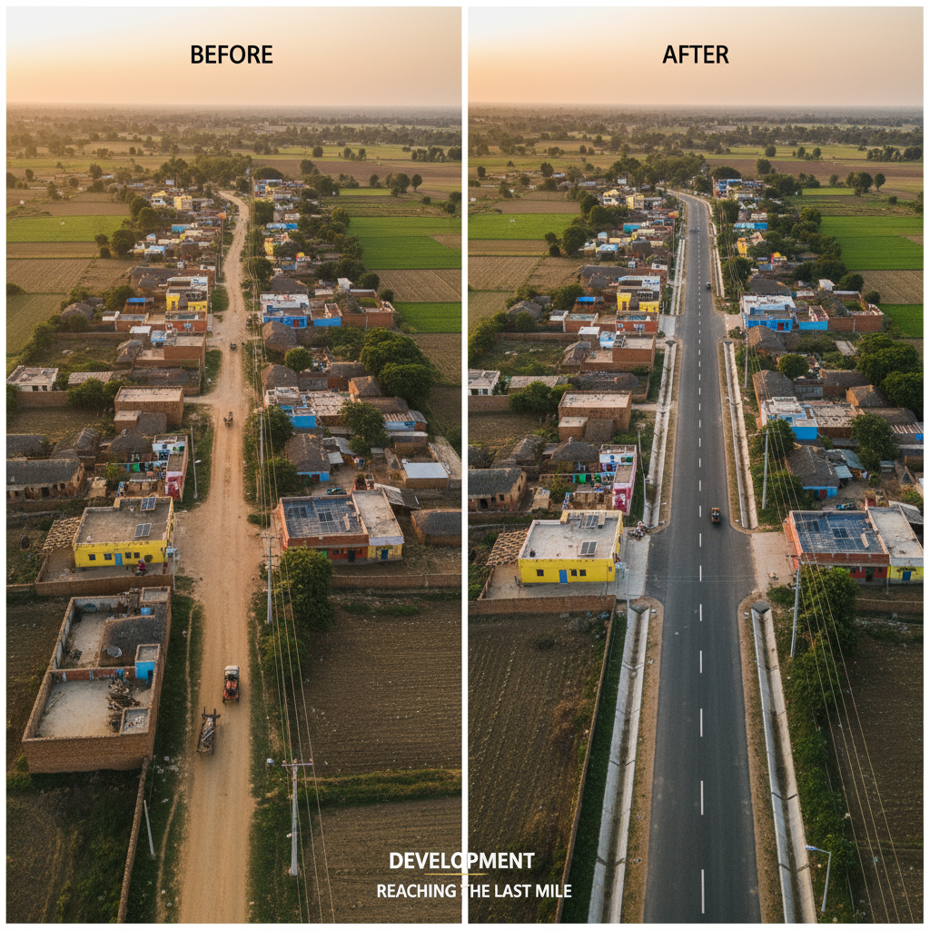
✅ Rural Transformation: 800,000+ rural facilities, 1 million+ habitations, 25 lakh km roads digitized under PMGSY integration; GIS data released in public domain February 2022
✅ Tangible Impact: India’s World Bank Logistics Performance Index ranking improved from 44 (2018) to 38 (2023); new technologies saving ₹5,000 crore in PMGSY implementation
✅ Scalable Model: 27 aspirational districts pilot implementation; plans to reach 750 districts; 533+ projects mapped; 20,000+ officials trained; showcased to 30 countries
GIS Layers—India’s Infrastructure Gets a Digital Brain
Imagine this: You’re planning to build a highway. But before breaking ground, you discover another ministry already scheduled underground gas pipelines along the same route—for next year. Without coordination, you’d build the road, they’d dig it up, causing cost overruns, delays, and public frustration. Multiply this scenario across 16 ministries, 750 districts, and thousands of projects, and you understand India’s historical infrastructure chaos.
Enter PM Gati Shakti National Master Plan—launched October 13, 2021 by Prime Minister Narendra Modi—a ₹100 lakh crore ($1.2 trillion) game-changing initiative that’s not just building infrastructure but revolutionizing how India plans, coordinates, and executes development. pmgatishakti.gov
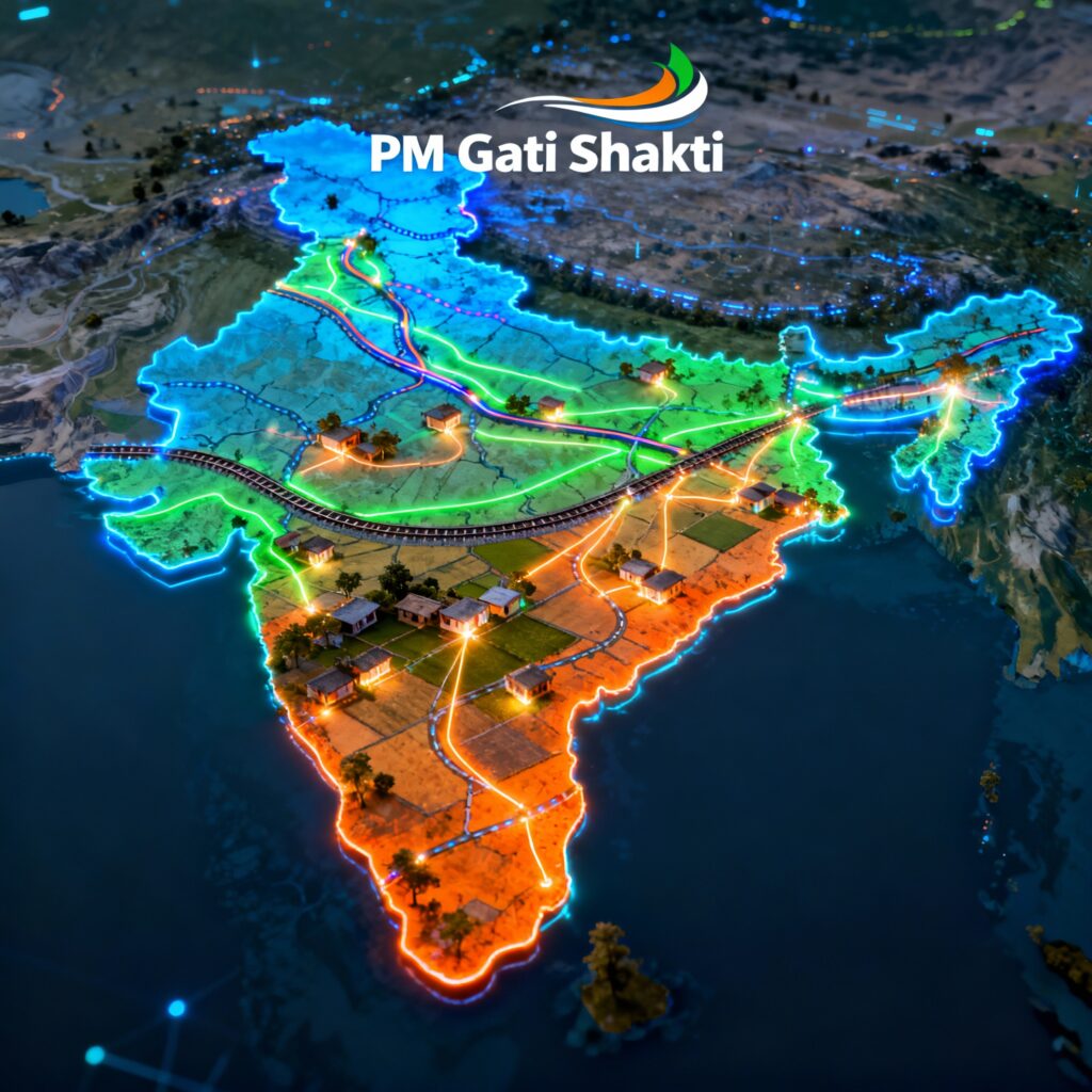
At its heart lies something deceptively simple yet profoundly transformative: Geographic Information System (GIS) technology with over 200 data layers creating India’s first-ever digital infrastructure brain.
The rural development dimension is staggering: 25 lakh kilometers of rural roads, 1 million+ habitations, 800,000+ facilities—all digitized and mapped under PMGSY integration, with data released in public domain in February 2022. This isn’t just digitization—it’s democratization of infrastructure planning, enabling startups, researchers, businesses, and citizens to leverage comprehensive rural connectivity data.
PM Gati Shakti exemplifies critical governance themes: infrastructure development, technology-driven administration, cooperative federalism, administrative reforms, breaking bureaucratic silos, and the intersection of spatial planning with inclusive development.
The Genesis: Why India Needed PM Gati Shakti
The Problem: Fragmented Infrastructure Planning
India’s infrastructure development historically suffered from departmental silos—each ministry planning independently without visibility into others’ activities: investindia.gov
Cost Overruns: Projects experiencing time and cost escalations due to lack of coordination (roads dug up post-construction for pipelines, telecom lines)
Logistics Inefficiency: India’s logistics cost at 13-14% of GDP compared to 8-10% in developed economies like Germany and Japan
Delayed Clearances: Projects waiting months/years for inter-ministerial approvals and environmental clearances
Suboptimal Routes: Infrastructure planned without comprehensive geographical data leading to longer routes, unnecessary forest clearance
Global Competitiveness: High logistics costs undermining India’s manufacturing and export competitiveness
The Vision: Integrated Multi-Modal Connectivity
PM Gati Shakti aims to create “holistic infrastructure” through:
Seven Economic Engines:
- Railways
- Roads
- Ports
- Waterways
- Airports
- Mass Transport
- Logistics Infrastructure
Supporting Infrastructure:
- Energy transmission
- IT communication
- Bulk water and sewerage
- Social infrastructure (schools, hospitals)
Integrated Programs:
- Bharatmala (roads)
- Sagarmala (ports)
- UDAN (airports)
- Inland waterways
- Economic zones (textile clusters, pharmaceutical hubs, defense corridors)
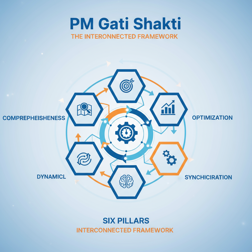
The Six-Pillar Framework: Architecture of Coordination
PM Gati Shakti rests on six foundational pillars ensuring coordinated infrastructure governance:
1. Comprehensiveness
Centralized Portal: Integrating existing and planned initiatives across all ministries
Unified Visibility: All departments gaining real-time insights into each other’s activities
Evidence-Based Planning: 200+ GIS layers providing comprehensive spatial data for informed decision-making
2. Prioritization
Cross-Sectoral Interaction: Enabling departments to prioritize projects through inter-ministerial coordination
Sequential Planning: Underground utilities (pipelines, cables) installed before road construction preventing costly rework
Avoiding Redundancy: Identifying overlaps and eliminating duplicate investments
3. Optimization
Gap Identification: Pinpointing critical infrastructure gaps in transportation, logistics, utilities
Route Optimization: Selecting most efficient routes minimizing time, cost, and environmental impact
Resource Efficiency: Optimal allocation preventing wastage and maximizing impact
4. Synchronization
Breaking Silos: Coordination across departments, ministries, and governance levels (central, state, district)
Preventing Delays: Eliminating bottlenecks caused by lack of inter-ministerial communication
Holistic Execution: Synchronized work schedules and phasing
5. Analytical
GIS-Based Spatial Planning: 200+ layers covering infrastructure, environment, economy, demographics
Enhanced Visibility: Satellite imagery and real-time data for executing agencies
Data-Driven Decisions: Replacing ad-hoc planning with evidence-based approaches
6. Dynamic
Real-Time Visualization: Live monitoring of cross-sectoral project progress
Satellite Imagery Updates: On-ground progress tracked through ISRO imagery
Adaptive Management: Periodic updates enabling course correction and responsive planning
BiSAG-N and the GIS Revolution
The Technology Backbone
Bhaskaracharya National Institute for Space Applications and Geoinformatics (BiSAG-N)—a Gujarat-based autonomous institute—developed the GIS-based digital platform powering PM Gati Shakti: pmgatishakti.gov
Platform Architecture:
- Open-source technologies ensuring accessibility and adaptability
- Hosted on MEGHRAJ—Government of India’s secure cloud infrastructure
- ISRO satellite imagery providing high-resolution spatial data
- Survey of India base maps for accurate geographical reference
- Dynamic mapping with real-time project updates

The GIS Layers: India’s Infrastructure DNA
The platform integrates over 200 geospatial data layers creating unprecedented infrastructure visibility:
Infrastructure Layers:
- Highways (national, state, rural)
- Railways (tracks, stations, yards)
- Airports (operational, under-construction, proposed)
- Ports (major, minor, inland)
- Inland waterways
- Pipelines (oil, gas, water)
- Power transmission lines
Environmental Layers:
- Forests (reserved, protected)
- Wildlife sanctuaries and national parks
- Eco-sensitive zones
- Water bodies (rivers, lakes, wetlands)
- Protected areas
Economic Zone Layers:
- Industrial corridors
- Special Economic Zones (SEZs)
- Textile clusters
- Pharmaceutical hubs
- Defense corridors
- Agricultural zones
Utility Layers:
- Power plants (thermal, hydro, solar, wind)
- Telecom networks and towers
- Digital infrastructure
- Water supply systems
- Sewerage networks
Administrative Layers:
- District and state boundaries
- Block and gram panchayat boundaries
- Habitations and villages
- Urban local body limits
1,000 Geospatial Maps:
- 450+ infrastructure datasets integrated as of 2022
- All maps interconnected enabling holistic cross-sectoral planning
- APIs allowing ministries to update data periodically
Operational Mechanism
Individual Ministry Login IDs: Each ministry/department updates its data on periodic basis maintaining real-time accuracy
Integrated Platform: All departmental data consolidated on single portal accessible for planning, review, monitoring
Decision Support Systems: Analytical tools for route planning, proximity measurement, Go/No-Go area identification, NOC requirement mapping
Satellite Monitoring: ISRO imagery providing on-ground progress updates enabling transparent monitoring
Rural Development Transformation: PMGSY Integration
The Massive Digitization Achievement
Pradhan Mantri Gram Sadak Yojana (PMGSY)—launched 2000 to provide all-weather rural connectivity—underwent comprehensive GIS digitization integrated with PM Gati Shakti:
Scale of Digitization:
- 800,000+ rural facilities geo-tagged as points (schools, hospitals, post offices, banks, markets)
- 1 million+ habitations mapped with precise coordinates
- 25 lakh km (2.5 million km) rural roads digitized with complete attributes
PMGSY Legacy:
- 7.83 lakh km roads sanctioned; 6.90 lakh km constructed
- ₹2.69 lakh crore expenditure (inception to 2022)
- 1,61,508 habitations connected with all-weather roads
- Last 7 years: Massive construction pace growth; new technologies saving ₹5,000 crore
Public Domain Release: Democratizing Data
On February 22, 2022, Union Minister Shri Giriraj Singh released Rural Connectivity GIS Data in public domain marking a watershed moment in transparent governance:
MoUs Signed:
- ESRI India
- MapmyIndia
- DataMeet
Collaboration: NRIDA (National Rural Infrastructure Development Agency) partnered with PM Gati Shakti for data exchange and coordinated planning
Beneficiaries:
- Startups and entrepreneurs: Product development and service innovation
- Businesses: Investment planning and market analysis
- Civil society: Research and advocacy
- Academics: Scholarly research and education
- Government departments: Inter-departmental planning
- Disaster response: Quick assessment and resource allocation
Atmanirbhar Bharat Vision: As Minister emphasized, “AtmaNirbhar Bharat can be achieved only by developing rural India by use of rural infrastructure data now available”
GeoSadak: Online Geospatial Transaction System
Under PMGSY-III, the GeoSadak application developed as Online Geospatial Transaction System enabling states to:
- Upload GIS data online
- Generate real-time reports
- Edit spatial data dynamically
- Monitor implementation quality
- Track financial progress
Comprehensive Data Portal: pmgsy-grris.nic.in provides complete geospatial information under PMGSY-I & II accessible publicly
District-Level Implementation: From Aspirational to National Scale
Aspirational Districts Pilot
PM Gati Shakti extended to 27 aspirational districts demonstrating bottom-up planning approach:
BiSAG-N Support: Technical assistance for district-level infrastructure planning using GIS tools
Case Study Examples:
Dahod, Gujarat:
- Satellite imagery analysis for planning low-cost drip irrigation systems
- Optimizing water resource use in water-scarce region
- Linking agricultural infrastructure to market connectivity
Arunachal Pradesh:
- Data visualization developing tourist potential around Bichom Dam
- Infrastructure planning connecting scenic locations
- Eco-tourism circuit development
Uttar Pradesh:
- Hospital site selection using spatial analysis of population distribution, existing facilities, road connectivity
- Wheat purchase center location optimization reducing farmer travel distance
- Agricultural logistics infrastructure planning
Urban Applications:
- Kanpur, Bengaluru, Srinagar: City logistics plans improving first and last-mile connectivity
- Integrating urban and rural supply chains
- Smart city infrastructure alignment
Scaling to 750 Districts
Expansion Plans: Rolling out district master plans to all 750 districts across India creating comprehensive national infrastructure framework
Capacity Building:
- 20,000+ officials trained through iGoT (Integrated Government Online Training) platform
- 150+ interactive sessions conducted
- Building geospatial competency across all governance levels
Institutional Integration:
- 36 states/UTs developed state master plans aligning with National Master Plan
- 533+ projects mapped on PM Gati Shakti portal for coordination
- State-center synchronization ensuring uniform standards
Sectoral Applications: GIS Empowering Rural Transformation
Agriculture and Irrigation
Digital Agricultural Stack: IoT, blockchain, GIS, Kisan drones, big data integrated for precision agriculture
Irrigation Infrastructure: Drip irrigation system planning using satellite imagery and soil analysis
Market Linkages: Agri-zones connectivity improvement through road and logistics infrastructure
Productivity Enhancement: Precision agriculture techniques leveraging geospatial data
Healthcare Infrastructure
Facility Mapping: Ministry of Health using NMP to identify internet-free areas and underserved regions
Site Optimization: Hospital location selection based on population distribution, accessibility, existing coverage
Telemedicine Planning: Digital connectivity infrastructure for remote healthcare delivery
Emergency Access: Ambulance routing and emergency response planning
Skill Development and Employment
Training Institute Location: Ministry of Skill Development identifying sites near industrial clusters and SEZs
Workforce Linking: Connecting rural workforce to employment opportunities through infrastructure
MGNREGA Integration: Geospatial tools assisting rural employment generation and asset creation
Skill-Market Alignment: Geographic mapping of industrial demand and training supply
Tourism Development
Potential Mapping: Tourist circuits around infrastructure projects (Bichom Dam example)
Rural Tourism: Heritage sites, eco-tourism locations connectivity enhancement
Circuit Development: Buddhist circuit, Ramayana circuit, coastal tourism routes integrated planning
Logistics and Storage
Cold Chain Infrastructure: Location optimization for cold storage facilities near production centers
Warehouse Networks: Strategic placement reducing transportation costs and post-harvest losses
First-Last Mile: Connectivity optimization between production, storage, and markets
Grain Procurement: Wheat/rice purchase center site selection minimizing farmer travel
Fisheries and Livestock
Fishing Harbor Connectivity: Linking fishing clusters to markets and processing units
Value Chain Infrastructure: Cold storage, ice plants, processing facilities spatially planned
Livestock Services: Veterinary centers, breeding facilities location optimization
Forestry and Environment
Sensitive Zone Mapping: Forest cover, wildlife corridors, eco-sensitive zones identified preventing unnecessary infrastructure through protected areas
Sustainable Development: Balancing infrastructure needs with conservation imperatives
Green Corridors: Ecological corridors maintained in transportation planning
Institutional Architecture: Cooperative Federalism in Action
Central Level Governance
Network Planning Group (NPG):
- 200+ major infrastructure projects evaluated
- Cross-ministerial coordination body
- Integrated planning ensuring sectoral synergies
- August 2025: 98th meeting evaluated seven projects including rail lines, highway expansions, logistics parks
Ministerial Integration:
- 44 ministries/departments integrated on single platform
- Breaking bureaucratic silos
- Coordinated decision-making and approval processes
Empowered Group of Secretaries (EGoS):
- Cabinet Secretary as chairperson
- Monitoring Master Plan implementation
- Approving changes meeting emerging requirements
- Demand-side interventions for bulk goods transport (steel, coal, fertilizer)
State and District Level
State Master Plans:
- All 36 states/UTs developed aligning with National Master Plan
- State infrastructure schemes integrated with central initiatives
- Uniform standards and protocols
District Implementation:
- 27 aspirational districts pilot phase
- 750 districts targeted for comprehensive coverage
- Bottom-up planning approach addressing regional disparities
Capacity Building:
- Mandatory training for district and block officials
- Field-based modules and hands-on sessions
- Institutional memory retention mechanisms
Impact Assessment: Tangible Outcomes
Logistics Performance Improvement
World Bank Ranking: India’s Logistics Performance Index ranking improved from 44 (2018) to 38 (2023)—six positions in five years
National Logistics Policy: Supported by Gati Shakti framework targeting single-digit logistics costs
Trade Facilitation: Export-import processes streamlined through coordinated infrastructure
Cost Savings and Efficiency
PMGSY Technology Adoption: New construction technologies and GIS planning resulting in ₹5,000 crore savings
Reduced Overruns: Coordinated planning preventing cost escalations from rework and delays
Taxpayer Value: Optimized resource allocation maximizing public investment impact
Global Recognition
International Showcase: Gati Shakti tool presented to 30 countries in Central Asia and Southeast Asia
UNESCAP Conference: Showcased at Hong Kong conference and Asia Pacific Business Forum
Diplomatic Engagements: Nepal, Bangladesh, Sri Lanka, Madagascar, Senegal, Gambia expressing interest in replicating model
South-South Cooperation: Technology transfer and capacity building for developing countries
Private Sector Integration
Union Budget 2025: Announced selective access to PM Gati Shakti portal data/maps for private players supporting project planning and PPPs
DPIIT Guidelines: Department for Promotion of Industry and Internal Trade framing secure-access framework
Investment Facilitation: Private sector using data for logistics and infrastructure investment decisions
Challenges and Implementation Barriers
Data Quality and Standardization
Consistency Issues: Ensuring uniformity across 200+ layers from multiple source agencies
Real-Time Updates: Establishing mechanisms for continuous data refreshment
Legacy Data Gaps: Addressing historical data incompleteness and inaccuracies
Digital Divide
Rural Connectivity: Limited internet access in remote areas hindering real-time portal use
Digital Literacy: Skills gaps among ground-level functionaries and community members
Device Affordability: Cost barriers for accessing and utilizing GIS tools
Capacity Constraints
GIS-Trained Personnel: Shortage at district and block levels requiring massive training investments
Skill Upgradation: Continuous learning needs as technology evolves
Institutional Memory: Retention challenges with bureaucratic transfers and retirements
Inter-Departmental Coordination
Cultural Resistance: Despite platform, hesitancy in information sharing persists in some departments
Active Usage: Ensuring all departments actively update and utilize data rather than passive compliance
Accountability: Mechanisms for enforcing data quality and timely updates
Financial Sustainability
Infrastructure Investment: High upfront costs for GIS systems, servers, software
Maintenance Costs: Ongoing expenses for updates, training, technical support
State Capacity: Resource-constrained states struggling with implementation expenses
Way Forward: Strategic Recommendations
1. Accelerate District-Level Rollout
Action: Fast-track master plan expansion to all 750 districts
Measures:
- Dedicated funding for district GIS infrastructure
- BiSAG-N technical support teams in each state
- Block and gram panchayat level planning integration
2. Deepen Rural-Urban Integration
MGNREGA Linkage: Connect PMGSY data with MGNREGA asset creation for comprehensive rural infrastructure
Mission Integration: Link with Jal Jeevan Mission, Swachh Bharat, housing schemes
Participatory GIS: Involve communities in planning through mobile apps and ground truthing
3. Enhance Private Sector Engagement
Data Access Framework: Finalize guidelines enabling secure private sector access to Gati Shakti data
PPP Models: Structured public-private partnerships for infrastructure development
Startup Ecosystem: Incubation support for geospatial innovation and rural tech solutions
4. Leverage Advanced Technologies
AI and Machine Learning: Predictive analytics for infrastructure demand forecasting
Mobile Applications: Field data collection tools for rural functionaries
Drone Mapping: High-resolution rural area mapping supplementing satellite imagery
5. Strengthen Monitoring and Evaluation
Real-Time Dashboards: Public dashboards tracking project progress and fund utilization
Third-Party Evaluation: Independent assessment of infrastructure quality and impact
Citizen Feedback: Integration of grievance redressal and community monitoring
6. International Cooperation
Technology Transfer: Expand Gati Shakti model sharing with neighboring and Global South countries
Capacity Building: Training programs for international officials
Diplomatic Leverage: Position India as geospatial governance leader
Conclusion: The Digital Infrastructure Imperative
PM Gati Shakti represents more than a ₹100 lakh crore infrastructure investment—it’s a paradigm shift in governance philosophy from fragmented departmentalism to integrated digital planning.
The rural transformation dimension is monumental: 25 lakh km roads, 1 million+ habitations, 800,000+ facilities digitized and democratized through public domain release, unlocking innovation potential for startups, researchers, and communities.
The six-pillar framework (comprehensiveness, prioritization, optimization, synchronization, analytical, dynamic) backed by 200+ GIS layers from BiSAG-N creates India’s first comprehensive digital infrastructure brain enabling evidence-based, coordinated decision-making.
Tangible outcomes validate the approach: Logistics ranking improved (44 to 38), ₹5,000 crore saved, 30 countries engaged, 20,000+ officials trained, 533+ projects coordinated.
Yet challenges persist: digital divide, capacity constraints, data standardization, inter-departmental cultural barriers, financial sustainability require sustained policy attention and resource commitments.
PM Gati Shakti exemplifies comprehensive governance reforms integrating technology (GIS, AI, satellite imagery), federalism (cooperative multi-level governance), infrastructure (seven economic engines), rural development (last-mile connectivity), and administrative reforms (breaking silos).
The ultimate vision—seamless multimodal connectivity reducing logistics costs from 13-14% to single digits, enhancing global competitiveness, transforming India into developed nation by 2047—depends on scaling PM Gati Shakti from pilot districts to every village, every gram panchayat, every habitation.
As Union Minister emphasized: Rural connectivity GIS data benefits startups, businesses, academics, government—“AtmaNirbhar Bharat achievable only by developing rural India”. PM Gati Shakti is making that vision tangible—one GIS layer, one digitized road, one connected village at a time.
The revolution has a name. The revolution has a map. The revolution is PM Gati Shakti—ensuring no village is left behind in India’s growth story.


+ There are no comments
Add yours