🌍 Why Satellites Matter More Than Ever
Every time you check Google Maps, watch live sports, or receive a weather update, you’re relying on a satellite silently orbiting hundreds of kilometers above Earth.
But how do these machines get up there? How do they stay in space without falling back—or flying away forever? And how do they send signals to Earth?
This article breaks down the science of satellites—from launch to orbit—in simple, beginner-friendly language, with examples and real-world applications.
🚀 Step 1: The Launch – Getting Off the Ground
📦 What Is a Satellite?
A satellite is any object that orbits another object. The Moon is Earth’s natural satellite. But when we say “satellite” today, we usually mean human-made satellites that orbit Earth for purposes like:
- GPS navigation
- Communication
- Earth observation
- Military surveillance
- Scientific research
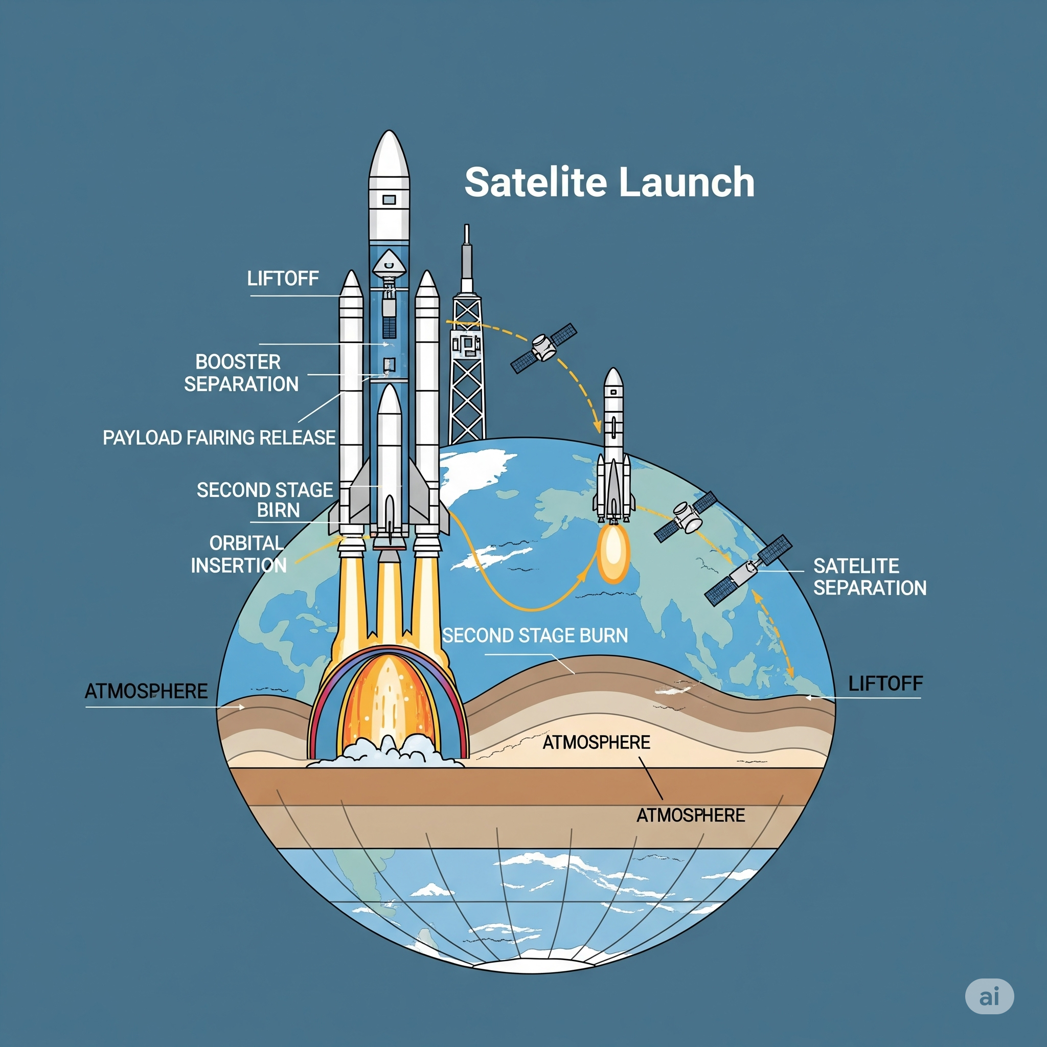
🚀 How Are Satellites Launched?
To reach space, satellites are loaded onto rockets, which carry them beyond Earth’s atmosphere. This requires incredible speed: about 28,000 km/h (17,500 mph) just to reach Low Earth Orbit (LEO).
🧪 Rocket Launch in Simple Steps:
- Liftoff: The rocket’s engines ignite, burning fuel to create upward thrust.
- Stage Separation: Most rockets have 2–3 stages that separate as fuel is used up, reducing weight.
- Orbit Insertion: Once above the atmosphere, the final stage places the satellite into orbit.
- Satellite Deployment: The satellite is released, unfolds antennas or solar panels, and activates onboard systems.
🛰️ Step 2: Finding the Right Orbit
🧭 What Is an Orbit?
An orbit is the curved path a satellite follows around Earth, balanced between gravity pulling it down and its forward speed keeping it moving sideways.
Think of it like swinging a ball on a string: gravity is the string, speed keeps it from falling.
🔄 Types of Orbits:
| Orbit Type | Altitude | Use Case |
|---|---|---|
| Low Earth Orbit (LEO) | 160–2,000 km | Earth imaging, Starlink, ISS |
| Medium Earth Orbit (MEO) | ~20,000 km | GPS satellites |
| Geostationary Orbit (GEO) | ~35,786 km | Weather, telecom, TV broadcasts |
| Polar/Sun-Synchronous Orbit | Passes over poles | Climate and mapping satellites |
🎯 Why the Orbit Matters
Each orbit is chose based on the satellite’s mission. For example:
- A weather satellite needs a constant view = GEO
- A spy satellite wants to see everywhere = polar orbit
- Internet satellites (like Starlink) need constellations in LEO for fast coverage
🔌 Step 3: Powering and Controlling the Satellite
☀️ How Do Satellites Get Power?
Most of the satellites are powered using solar panels. These convert sunlight into electricity, which is stored in onboard batteries.
During eclipses or in shadow, the satellite runs on this stored energy.
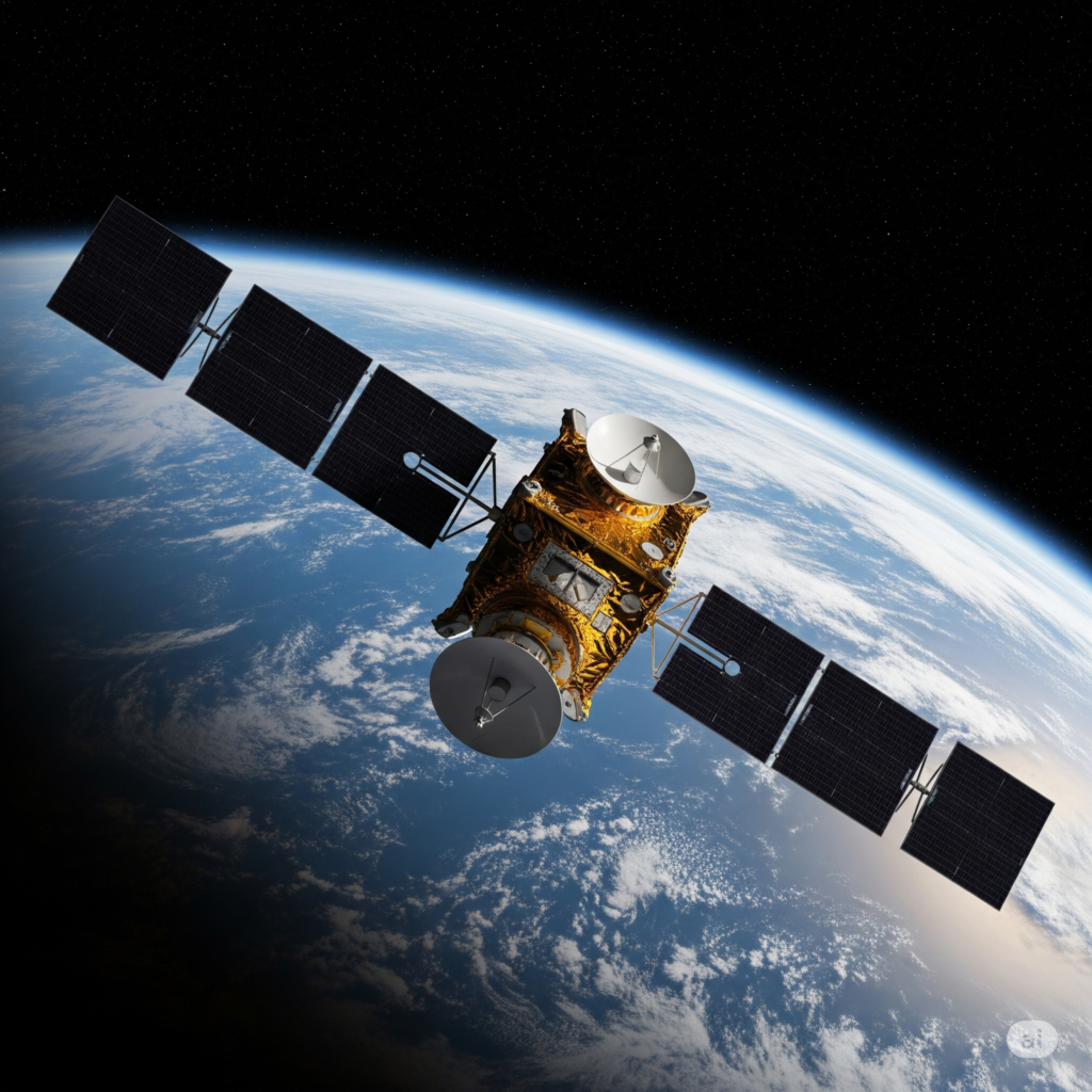
🧠 What’s Inside a Satellite?
Most satellites include:
- Antennas (for communication)
- Thrusters (for course correction)
- Gyroscopes (for orientation)
- Onboard computers
- Sensors (temperature, radiation, motion)
- Payloads (camera, radar, telescope, etc.)
📡 Step 4: Communicating with Earth
Satellites communicate using radio waves or laser signals. These signals are sent to ground stations, which decode the data.
Examples of Communication:
- 📺 A TV satellite sends video signals to your home dish
- 🌦️ A weather satellite sends cloud images to meteorologists
- 📡 A GPS satellite transmits time/location signals to your phone
Fun Fact: Some satellites can “talk” to each other in space using inter-satellite links!
🕹️ How Are Satellites Controlled?
Satellites are usually semi-autonomous—they perform daily operations on their own but receive:
- Commands from Earth
- Software updates remotely
- Orbit adjustments via onboard thrusters
Satellite operators track them from mission control centers, which monitor health, position, and performance.
🌐 Real-World Examples of Satellites in Action
1. ISRO’s Cartosat Series (India)
Used for mapping, infrastructure, and disaster response.
Resides in sun-synchronous orbit.
2. Starlink (SpaceX)
Thousands of small LEO satellites creating a global high-speed internet network.
3. NOAA GOES Satellites (USA)
Geostationary weather satellites providing real-time forecasts and storm tracking.
4. NAVIC (India’s GPS Alternative)
Regional positioning system built by ISRO. Uses satellites in GEO and MEO.
🌌 How Satellites Stay in Orbit Without Falling
Satellites are kept in orbit by a delicate balance between gravity and speed.
- Too slow = falls back to Earth
- Too fast = escapes into space
Satellites don’t need constant thrust—they’re essentially “free-falling” around Earth due to gravity’s pull.
🚀 Newton’s first law: An object in motion stays in motion unless acted upon.
🧹 End of Life: What Happens When a Satellite Dies?
Satellites don’t last forever. Their lifespan ranges from 5 to 20+ years.
🔚 What happens next?
- Deorbit and burn up in the atmosphere (for LEO satellites)
- Graveyard orbit (for GEO satellites, parked far from Earth)
- Some become space junk—a growing concern for future missions
🧠 Final Thoughts: From Earth to Space—and Back to You
Satellites are the invisible infrastructure of the modern world.
They help us forecast weather, connect rural villages, predict disasters, and even track endangered species.
Understanding how they work—from launch to orbit to signal—gives us a better appreciation for the technology that powers everything from smartphones to science.
🌏 Satellites may orbit far above us, but their impact is felt every day.


+ There are no comments
Add yours